
Author: R. Busonera
Download article as .pdf: Il contributo della cartografia storica per lo studio del territorio di Villa Adriana
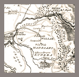 Relating to many studies on the architecture of Villa Adriana, the discussion on the problems linked to the place that Hadrian chose for its construction appears still suspended. A reinterpretation of the issue arises from the aid of historical cartography, which is useful for a framework of natural resources of which the whole complex could achieve, as well as in reference to the anthropic settlement and the connections opportunities with Rome. These are documents whose graphic synthesis certainly refers to the natural features of the territory, but also to the signs of human actions no longer perceptible. Essential topics within a research that requires a territorial approach that can convey the collection of data towards a long-term settlement process.